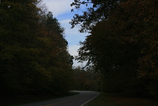
We continued investigating various locations on the Natchez
Trace Parkway as we drove from Hohenwald to Tupelo. The Trace along the northern part is very
beautiful with a canopy of trees over the road.
The nice thing about the road is that there are no commercial vehicles
permitted so we didn’t have to worry about semi’s zooming around us.
There is so much history along the parkway and we didn’t
have time to stop at every brown sign along the way. One of the stops that we did make while
pulling the 5-wheel was at Pharr Mounds.
The eight burial mounds were built from about 1,800 to 2,000 years
ago. According to the informational
sign, the builders of these mounds probably knew little about farming and
relied entirely on hunting, fishing and gathering berries.
After settling into the Natchez Trace RV Park (in the rain
as usual) for our stay of a couple of days, we spent the rest of the day
relaxing and planning our tour for the next day. The next day we saw more Indian mounds—Bynum Mounds
which were built by prehistoric people between 2,100 and 1,800 years ago.
We were able to walk around the preserved
site to see the mounds up close. By far
the most interesting mounds were the Owl Creek Mounds. This was a ceremonial site and built/used by
farming people belonging to the Mississippian culture A.D. 1000 to 1500. The archaeological site was originally
composed of five Indian mounds, a central plaza, village area and other key
features. Many of these have disappeared over the years, but the central two
mounds remain and are preserved in a park area that also features walkways,
interpretive panels and a picnic area (see http://www.exploresouthernhistory.com/natchezowlcreek.html
for additional information.) The larger
of the mounds has steps to the top that gives a panoramic view of the
surrounding area and of the other mound.
After seeing the mounds, we started visiting Civil War
Battlefield and Cemetery sites. North of Tupelo is Brice’s Cross Roads
National Battlefield Site (June 10, 1864) and Cemetery. The Confederate victory at Brice’s Cross
Roads was a significant victory for Major General Nathan Bedford Forrest, but
its long term effect on the war proved costly for the Confederates. Brice’s
Cross Roads is an excellent example of winning the battle, but losing the war.
For more information, go to http://www.nps.gov/brcr/index.htm.
Tupelo was the site of another Civil War battle on July
14-15, 1864 between Maj. Gen. Andrew J. Smith for the Union and Maj. Gen.
Nathan Bedford Forrest who had previously pushed back the Union troops at Brice’s
Crossroads. The purpose for the fighting
in Mississippi during the summer of 1864 was to protect the railroad carrying
food and ammunition from Louisville and Chattanooga to the union army advancing
on Atlanta. While neither side can claim
complete victory at Tupelo, the Union army did keep Forrest in Mississippi allowing
Sherman to continue his march to the sea.
After our brief stay in the Tupelo area, we proceeded south
along the Natchez Trace before heading west to Greenville, MS. While driving along the Trace, the road
looked much the same as we had seen previously until we came upon a sign the
said “Tornado Damage April 2011”. The
damage went for miles and miles and made the area look like a war zone. It appears that the tornado that ripped
through the area traveled along the Natchez Trace destroying everything in its
path. How awesome nature can be in both
good ways as well as those possibly perceived to be bad.
We arrived at Chicot County Park in Lake Village, AR on
October 25, 2011. Our continuing
adventures will be posted on another day.
EASY LIVING!!


No comments:
Post a Comment